


.png)


In early September 2020, an intense heatwave broke temperature records in several locations in Southern California. The dry, hot conditions helped fuel new and existing fires, which have consumed tens of thousands of acres of land. According to recently published research, these extremes fit a long-term trend toward longer and more intense heatwaves in Southern California.
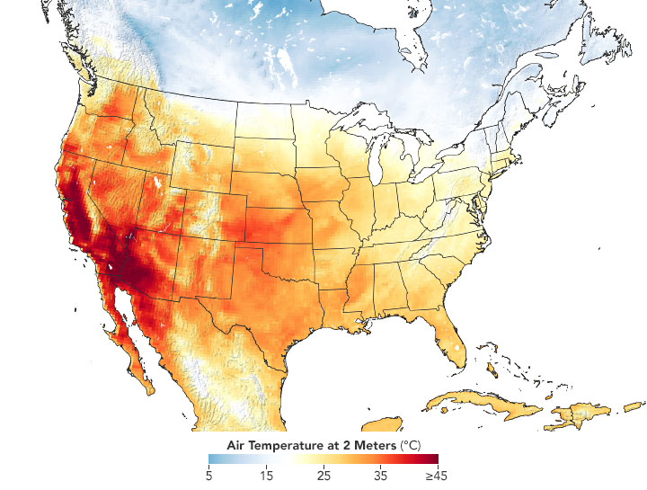
The map above shows air temperatures across the United States on September 6, 2020, when much of the Southwest roasted in a dramatic heatwave. The map was derived from the Goddard Earth Observing System (GEOS) model and represents temperatures at 2 meters (about 6.5 feet) above the ground. The darkest red areas are where the model shows temperatures surpassing 113°F (45°C).
On September 6, 2020, around 1:30 p.m., Los Angeles County recorded its highest temperature ever at 121°F (49°C) at Woodland Hills. Several other cities, like Paso Robles and Palmdale, also hit record highs.
The map below shows land surface temperatures (LSTs) on September 6 near San Bernardino National Forest. The data come from NASA’s ECOsystem Spaceborne Thermal Radiometer Experiment on Space Station (ECOSTRESS), which uses a scanning radiometer to measure thermal infrared energy emitted from Earth’s surface. Note that LSTs are not the same as air temperatures: They reflect how hot the surface of the Earth would feel to the touch and can sometimes be significantly hotter or cooler than air temperatures. (The map also captures the El Dorado fire, which had burned more than 11,000 acres and was 19 percent contained as of September 9.)
No hay comentarios:
Publicar un comentario